Gabcikovo Water Project |
The construction started under the so-called ”Mutual Agreement Project” which was outlined by both parties in 1976 and created a technical background for an international treaty in 1977. On its basis, the Hungarian party outlined the performance projects. For the Czechoslovak party, this was a background for an initial project development. This project already contained the so-called ‘national investments’, arrangements excluded from the mutual investments. Only the constructions agreed on as mutual investments served as the background for work assignments and a half-to-half share of their finance. Since a greater part of the water project was located on the Slovak territory, in order to follow an equal share of costs, the Hungarian party had to build a part of Gabcikovo constructions located on the Slovak territory. Later, when the Hungarian party abandoned the works on the construction, the Slovak party completed their part and that part of the Gabcikovo Water Project which was located on the Hungarian territory was replaced by a solution enabling to complete and activate the Gabcikovo Water Project by arrangements built on the Slovak territory. This solution was named ”Putting of the Gabcikovo Water Project Into Operation by a Temporary Solution”, better known as ” variant ‘C’”. The chosen solution was placed amongst seven variants considered and marked as ”A” to ”G”.
Built as an reconstruction of existing Danube dikes and, in some sections, a construction of new dikes. It consists of:
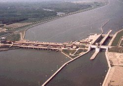
is located on the Hungarian territory. On the right, it is connected to the right side dike of the basin and damming of the Danube channel which is already a part of the so-called ‘connection dike’. The weir has seven fields barred by segments with a flap. It contains a lock chamber which was to safeguard the navigation when this needed to be conducted in the Danube channel. The weir had to serve damming-up of the water level in the basin at 131.20 m above Baltic, the flood and ice discharges and to provide a sanitary discharge set up to 50 m3/sec (later 200 m3/sec) to old Danube channel. Originally, the energy of water discharged to old river channel was not considered. The Hungarian party constructed the weir and the connection dike already situated on the Slovak territory which connects the planned damming of the Danube channel by a right side headrace canal dike. However, this dike has not been completed. by the Hungarian party. As a part of its delivery, they have constructed an about 1.5 km guiding dike for guiding the ice runs to Dunakiliti weir.
The headrace canal dikes follow the Hrusov basin dikes and end at Gabcikovo river step with the right side dike connecting to the right inflow wing of the hydropower plant and the left side dike to the left side wall of upper lock-headrace of penstocks. The canal is 17 kilometers wide, with varying widths between 267 – 737 metres on the bottom and water depths of 7.3 – 14.3 m. The crests of both dikes are horizontal with altitude 133.10 m above Baltic. The canal’s dikes are made from ballast with a 6.0 m wide crest lined by rasin apron. The canal is waterproof due to asphalt and concrete sealing of the dike slopes and bottom foil sealing. The canal’s dimensions suit for maximum flow rate 5,300 m3/sec at the end of peak operations.
Alongside the dike’s downstream toes lead the seepage canals with the backwater constructions and withdrawal constructions on the left side to supply the irrigation canals of the Danube Island with water. Right side seepage canal outlets to drainage canal, left side outlets to irrigation canal S VII near Gabcikovo river step but the crucial amount of discharge is directed to the Danube inundation by a sluice under the headrace canal channel. The sluice has 5 holes, 4 water holes and the fifth for cable wires (dry). Total maximum amount of passing water is 22.0 m3/sec before the colmatation and 8.0 m3/sec after it.
 The step makes use of
hydroenergetic fallout possible and provides international navigation by overcoming level
differences between the headrace and drainage canals by lock chambers.
The step makes use of
hydroenergetic fallout possible and provides international navigation by overcoming level
differences between the headrace and drainage canals by lock chambers.
Hydropower plant consists of four double blocks with 8 installed hydropower units. Hydropower units are composed by vertical Kaplan turbines with a diameter of impeller 9.3 m and generators connected to them on common axles. Installed output of one hydropower unit is 90 MW.
Lock chambers enable to overcome the height difference of levels between the headrace and drainage canal in range of 16 – 23.3 metre. Each is 34.0 m wide and 275.0 m long. Segment gates are installed on the upper head, the lower head is barred by turning gates. Filling and draining system consists of influx placed outside of upper lock approach with sill on 119.00 m above Baltic, bypass and outlet with bottom on 97.00 m above Baltic. Influx and outlet canals sized 4x4 m are barred by segment gates.
Filling and draining of lock chambers takes about 15 minutes. Navigation is guided from the tower placed on the central pillar of the chambers. Outlet from lock chambers when drained is directed outside the lower lock approach, to water power plant outcrop.
The canal begins below the Gabcikovo river step and streams to the Danube at Palkovicovo (Sap). It is to divert discharges from the headrace canal to the Danube up to a volume of 5.300 m3/sec. It is 8.2 km long, 16.0 m deep with bottom width of 185.00 m, on berm level 322.00 m. Water slopes are lined by 70 cm thick rock fill within the range of water level rocking.

After the Hungarian party announced final abandoning of the works on the Gabcikovo-Nagymaros Water Projects System, the Czechoslovak party sought a solution of best use of investments put into the construction of the Gabcikovo Water Project which was that time constructed at 90%. Having considered 7 alternatives (with 15 subalternatives), the Czechoslovak party decided to implement the third variant (signed as ”C”) called ”Putting of the Gabcikovo Water Project Into Operation by a Temporary Solution”. How does it differ from the original solution? Mainly, that it contains a solution which dams up water and diverts it into derivation by construction of buildings wholly located on the Slovak territory. From the original solution of the Gabcikovo Water Project, only the following constructions are being utilized:
Arrangements under variant ”C” start with construction of 850 m long first part of basin dike connected to the original right side dike of Hrusov basin approximately at Cunovo, before the state border with the Republic of Hungary. The first part of this ”Right side basin dike on the right bank of the Danube” is linked with ”Withdrawal Project into Moson Branch”. Second part of this dike, 145 m long, is a connection between the withdrawal project and ”Weir in Inundation”. This weir is linked to ”Weir Water Power Plant” with output of 22.4 MW, absorption power of 400 m3/sec that is already a part of ”Three-pole Weir and Assistance Lock Chamber”. Between this weir and a ”Bypass Weir”, there is a body of bank ”Damming up of the Danube channel” with integrated Water Sports Centre. Bypass weir is further linked to ”Right side basin dike on the left side of the Danube” which closes the change of original solution of Hrusov basin by linking to connection dike. Therefore, under this variant ”C” only the solution of right side of Hrusov basin changes.
The costs of variant ”C” are quoted in 1993 price level as approx. 6.0 mld SKK. They include:
![]()
![]() - Last modified: 03. 07. 2001
- Last modified: 03. 07. 2001